Open Source · Self-Hosted · OGC API
The self-hosted catalog and map builder for your geospatial data
GeoLens is an open-source, self-hosted catalog and map builder for geospatial data. Search and preview datasets, compose multi-layer maps with 3D terrain, and serve them over open OGC APIs — all on infrastructure you control, with no telemetry.
Built on PostGIS · MapLibre · Titiler · FastAPI Open standards OGC API · STAC · DCAT
Search & Discover
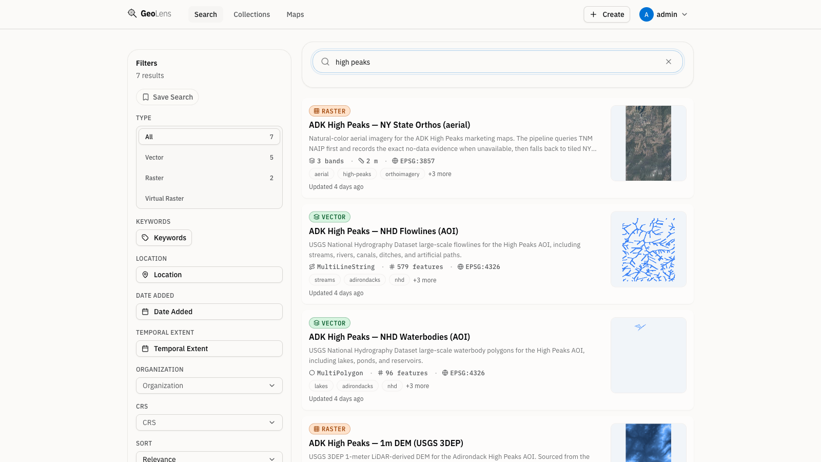
Find any dataset in seconds
Search across your entire GeoLens catalog by name and description — and, when an embedding provider is configured, by semantic meaning so related datasets surface even when the exact words differ. Filter by geometry type - vector, raster, or table - and preview datasets on a map before you download.
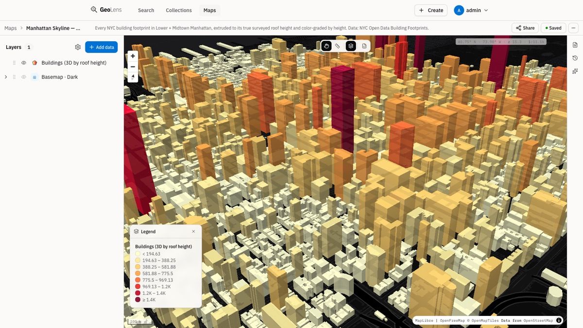
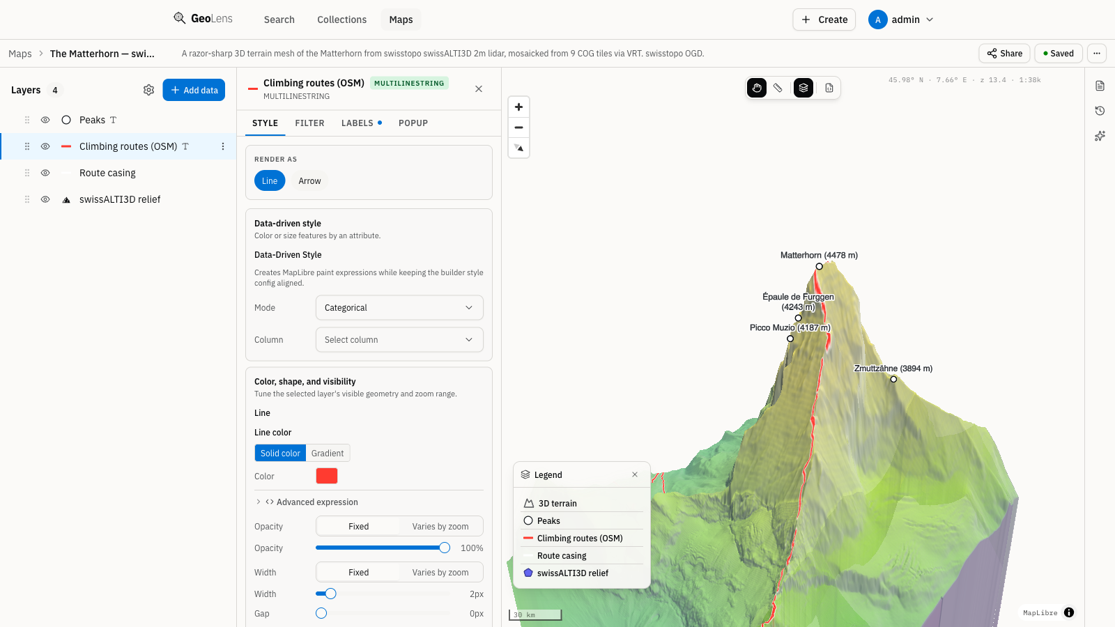
Create & Share Maps
Compose multi-layer maps in minutes
Combine vector and raster datasets with point-and-click layer controls — reorder layers, set color ramps and filters, draw and edit features, switch basemaps, and tilt into 3D terrain. Then share a live map with a signed link, or embed it in any page with a secure, expiring token — no SQL, no leaving the browser.
10-minute deploy
One command. Your data, your infrastructure.
No cloud account required. The full platform is open source under Apache 2.0 — the entire catalog, map builder, and APIs, free to self-host. Run on a laptop, a single VM, or your own servers with Docker Compose — a community-maintained Helm chart is available for Kubernetes.
How it works
One stack. One docker compose up.
Every GeoLens deployment is the same handful of services, orchestrated by a single compose file — no external search engine, no separate tile server to run.
- 1
Frontend
React + MapLibre UI — catalog, map builder, and 3D.
- 2
API
FastAPI — REST, OGC API, and tile endpoints.
- 3
Catalog & search
PostgreSQL + PostGIS + pgvector — spatial and semantic in one database.
- 4
Raster tiles
Titiler — Cloud-Optimized GeoTIFF tiling.
What GeoLens does
Everything your team needs to work with geospatial data
Search & Semantic Discovery
Find any dataset with full-text search, plus optional vector semantic ranking when you configure an embedding provider. Filter by geometry type, CRS, or date. No SQL required.
Map builder & sharing
Compose multi-layer maps in minutes, then share them with a signed link or embed a live, interactive map in any page with a secure token.
3D Terrain
Bind a DEM and tilt into 3D — hillshade, terrain exaggeration, and your choice of basemap in the built-in map builder, powered by MapLibre. No desktop GIS required.
Raster & COG tiles
Ingest Cloud-Optimized GeoTIFFs and large rasters, build VRT mosaics, and serve tiles via Titiler with automatic colormaps — no separate tile server.
AI assist (optional)
Connect your own OpenAI or Anthropic key to explore your catalog in plain language, generate maps, and draft dataset descriptions. Optional and off by default — GeoLens runs fully without it.
OGC API
Serve your datasets over OGC API - Features and Records, with CQL2 filtering and direct tile URLs for map clients. Compatible with QGIS, ArcGIS, and OGC clients.
Data ingestion
Drop in shapefiles, GeoTIFFs, GeoJSON, GeoPackages, COGs, and CSV. GeoLens validates, detects CRS, and indexes for you.
Self-hosted
Docker Compose on a laptop, a VM, or your own servers — the supported path. A community-maintained Helm chart is available for Kubernetes. Your infrastructure, your data; no cloud account required.
RBAC & access control
Admin, editor, and viewer roles with per-dataset permissions. OAuth (Google, Microsoft, OIDC) and JWT sessions. Audit log included.
Why GeoLens
A modern alternative to heavyweight GIS stacks
One command, not a server farm
A single docker compose stack stands up the catalog, API, tiles, and UI — not a multi-image orchestration project.
A modern UI, by default
A React + MapLibre interface with a real map builder — not an afterthought UI on top of a data store.
Standards included, never paywalled
OGC API, STAC, and DCAT ship in the box, so your data stays portable and your existing clients keep working.
Your infrastructure, your data
Self-host on a laptop, a VM, or Kubernetes — even fully offline or air-gapped. No cloud account and no telemetry — outbound traffic only from the integrations you enable (AI, SSO, SMTP, basemaps, remote data). Plus an audit log of who did what.
Works with the tools you already run
Point QGIS or ArcGIS Pro straight at your OGC API URL — no format conversion, no plugin. GeoLens fits alongside your existing stack instead of replacing it.
No lock-in, a clean exit
Your data stays in standard PostGIS and open formats, reachable and exportable over OGC API, STAC, and DCAT — so you can walk in, and out, without a migration project.
Who it's for
Built for teams that work with spatial data
GIS analysts & teams
Replace the tangle of shapefiles on a shared drive with one searchable catalog your whole team can preview, style, and share.
Data engineers
Serve datasets as OGC API Features, tiles, and STAC — straight into QGIS, ArcGIS, or your own clients, and script it all with the CLI.
Government & utilities
Keep sensitive data on your own network — on-prem or air-gapped, with no telemetry; point basemaps at internal tiles for zero third-party egress. Role-based access, per-dataset scoping, and a full audit log are built in.
Civic tech & research
Publish open data catalogs on a permissive Apache 2.0 stack — no licensing cost, no vendor lock-in.
Up and running in under 10 minutes
Clone the repo, run the installer, log in, and upload your first dataset — the Quickstart walks through every step.
Read the Quickstart Integrate via the APIOr script it: automate GeoLens from the command line or your own code.